Well, not all the streets have no name. The larger ones do. But most don’t.
Japan’s streets are usually not laid out in a rectangular grid like American streets more often are. The blocks seem to be divided in a much more haphazard fashion, like people just claimed this bit of land or that, and the streets just flowed around them. This by itself is enough to confuse any non-native person navigating Japan’s streets, but the fact that most streets have no name, no street signs to guide your way makes it even more difficult. Because streets tend to jig this way and jag that way, it is very easy to lose your sense of direction–I’ve done that more than once, and I’ve got a fairly good sense of direction.
Here’s how it’s laid out. You start with a city block (called a “banchi“), which has a certain number of lots on it. Each lot has a number. The numbering begins at some point on the block, then runs around that block ascending, until you reach the starting point again. Not all numbers are used, and the pattern–if there is one–is hard to see. Certainly not like the U.S. system where even and odd numbers are used on either side of the street. And the block is not usually going to be a rectangle, and the lots are often uneven Rarely are they organized, and usually very different kinds of buildings share the same block–you can have an apartment building next to a factory next to a wealthy person’s home next to a convenience store next to a few regular houses and then a trucking company, and so on. Okay, usually it’s not that diverse, but after seeing so many neighborhoods in Japan, you get the clear sense that zoning is not a big thing here.
Next, the blocks are grouped together into divisions of the “neighborhood,” as you might call it. Each division is called a “chome” and is made up of some dozens of blocks. Each block has its own number, and while they usually are sequential, that sequence may wander and meander somewhat. You could be walking down a street, and come to an intersection, and even though all four visible blocks are in the same division, they might have numbers like 7, 8, 21 and 34. The sequence of numbering is usually most apparent on a map, not from the ground. There seems to be no universal logic to how the block numbers are assigned.
Each “neighborhood” (called a “cho” or “machi“) is divided up into anywhere from one to perhaps even a dozen “chome.” Usually the number of chome is four or five, but there are all kinds of variations, again seeming to follow rather non-standard rules, if there are any rules to this.
Finally, put all the neighborhoods together and you get a ward/borough (“ku“), or some sort of village, town or city (“mura,” “machi” or “shi,” respectively). These then collect to form a prefecture, kind of like a state or a province.
In the U.S., our addresses are initially linear–using streets–but then go to a radial zooming-out system. In Japan, addresses are purely radial. First there is the building number, then the block number, then the neighborhood division number, then the neighborhood, city/ward, prefecture and country.
Take the map fragment, from Machida City, shown below:
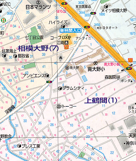
This focuses on the area shared by two neighborhood divisions: the orange 7th chome of Sagami Ohno Neighborhood at top, and below, the pinkish 1st chome of Kami Tsuruma Neighborhood. The big bright orange line is a major boulevard, so it’ll have a name (Tokyo Kanjou, or the Tokyo Ring Road). You can see that it is intersected by a semi-largish white road; sometimes a road that size has a name, but not this time–the Tokyo Ring Road is the only named street on this part of the map. The blue numbers are block numbers, and the smaller red ones are lot numbers. Note the “block” numbers for the uppermost neighborhood above the orange road: the numbers are in the thousands, indicating that it is a neighborhood (machi) with no divisions (chome); in this case, there are no division numbers and even no block numbers–each number is a lot number. So instead of having an address like 7-31-22, the number is just something like 1880.
You might think that the block numbers and lot numbers could help, but these are not always easy to spot on the ground. The closest thing to street signs in most places in Japan are small placards on telephone poles which, along with local advertising, show the address down to the block number. But these are too small to note while driving, and even when walking, they are sometimes absent; people rarely use them for directions. Some residences will have the address on a small plate on the outside wall of the lot, but that is the exception, not the rule.
Now, there are some landmarks to assist you. Note the blue box with the white letters; that’s the name of the intersection. Intersection names can be a help as they do not depend on street names, but as you can see, there are not many of them. So what we are left with are landmarks. You can see two McDonald’s, a 7-11, and a supermarket (“Coop,” right at the named intersection). After that, you have to depend on traffic lights, pedestrian overpasses, schools (the brown buildings just above left of center are an elementary school), hospitals (the cross-in-a-shield mark at center right is one, the Mori Clinic), car dealerships (trust me, there’s a Toyota and a Honda dealership in there), and so on. So directions from point A to point B are heavy on landmarks. “Go two traffic lights down, take a left and when you see the fire station, take the next right. The place you’re looking for is about 30 meters down the road, just after the small park on your left.”
Needless to say, a lot of people get lost. Especially when maps provided by businesses are heavily distorted in terms of distances and relative positions.
You can also see on this map the haphazard layout of blocks and streets. And you can see the variety of buildings in a small area. Take the Coop supermarket: above it is an apartment block, and above that is a factory (marked by the circle with what looks like a Roman numeral “I” in it). Just below it on the map is a fire station, across from which is a kindergarten. Kitty-corner from the Coop across the intersection is the Toyota dealership, and across from that is a pharmaceutical company. In all the vacant spaces are houses and any number of small shops, warehouses, apartments, and so on. In short, it’s a mess. But people get by somehow.